Welcome to Upper Arroyo Seco Trail
So, what did I do this weekend? I went hiking, of course.
Saturday I did a fairly easy local trail that I have walked so often I could probably do it in my sleep. To make it a little more challenging though, I weighted down my backpack and managed to get a little bit of a workout for a change.
Monday my roommate decided he wanted to try his hand at hiking too, so we headed off to the Upper Arroyo Seco Trailhead.
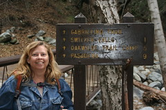
Upper Arroyo Seco Trailhead
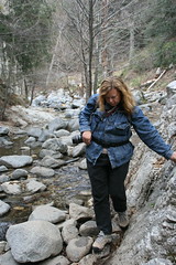
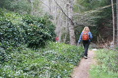
According to the information I pulled off the web, this is a moderate hike. According to the local ranger, it is an easy hike. I haven't pulled out my trail book yet to see what it says, but I have a gut feeling that the classification for this trail is highly dependent on the time of year you choose to hike it and how much of the trail has been washed away by the previous year's runoff. This time of year, with the water in the river low (I'd call it a creek in parts) this is a very rocky, bouldery trail. If you are not paying attention it is very easy to lose your footing and end up wet or injured, or both. Yep, you have to boulder/rock hop across the water several times in order to follow the trail or get around the washed out parts.
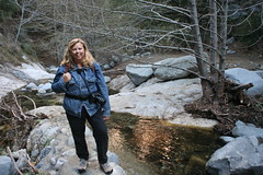
And, if you're wondering why the person in the photos is so bundled up, well, it had snowed the night before and was quite cold.
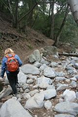
Picking way through winter landslide
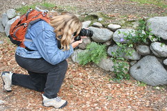
Nature photographer at work
Alternative route to washed out trail
Decaying rock and concrete wall becomes bridge
Just above Switzer Falls
Saturday I did a fairly easy local trail that I have walked so often I could probably do it in my sleep. To make it a little more challenging though, I weighted down my backpack and managed to get a little bit of a workout for a change.
Monday my roommate decided he wanted to try his hand at hiking too, so we headed off to the Upper Arroyo Seco Trailhead.
According to the information I pulled off the web, this is a moderate hike. According to the local ranger, it is an easy hike. I haven't pulled out my trail book yet to see what it says, but I have a gut feeling that the classification for this trail is highly dependent on the time of year you choose to hike it and how much of the trail has been washed away by the previous year's runoff. This time of year, with the water in the river low (I'd call it a creek in parts) this is a very rocky, bouldery trail. If you are not paying attention it is very easy to lose your footing and end up wet or injured, or both. Yep, you have to boulder/rock hop across the water several times in order to follow the trail or get around the washed out parts.
And, if you're wondering why the person in the photos is so bundled up, well, it had snowed the night before and was quite cold.


2 Comments:
Wow, the photos make it appear to be a beautiful hike!
What is the distance you hiked? And how difficult (of a hike) do you think it is?
And, finally,is that you in the photos, Zara...?
It is a beautiful hike. The photos actually don't do it justice.
Sorry, not telling who the person in the photos is--I promised I wouldn't. :-)
The total hike is 10 miles in and out. We got a late start and got lost on the way there, so we were only able to do about 2.5 miles before dark. We are going back earlier next weekend. It was fun and I need a good trail hike at altitude.
I'd say the trail is a combination of easy and moderate, with some difficult, but not strenuous sections--at least what I have seen of it. And, yes, I did get wet. A river rock slipped out from under my shoe--the rock moved, I didn't slip, but I nearly took a complete and very cold bath. But heck, when water runs through a trail you are probably going to get wet at some point. It was an excellent test for the new shoes--no skids, no slips, no slides.
You hike down into a valley to Switzer falls, and then back up again, past another fall, and ending at Oakwilde Trail Camp. A total of approximately 1400 ft change in elevation. I'm not certain what the starting elevation is. From Oakwilde you can,if you want, hike 5 miles down to Pasadena on the Lower Arroyo Seco Trail (another 900ft or so elevation change). Your car though will be at the upper trailhead, so it really doesn't make much sense to do that unless you have someone to drop you at one head and pick you up at the other.
From what I understand, most visitors never leave Switzer Picnic ground, and of the few that do, only a handful actually make it to Switzer Falls, and even fewer go on to Oakwilde. Yesterday, there were very few people period. Most visitors to the area were driving up to the snow, which was a mile or two more up the road.
Post a Comment
<< Home